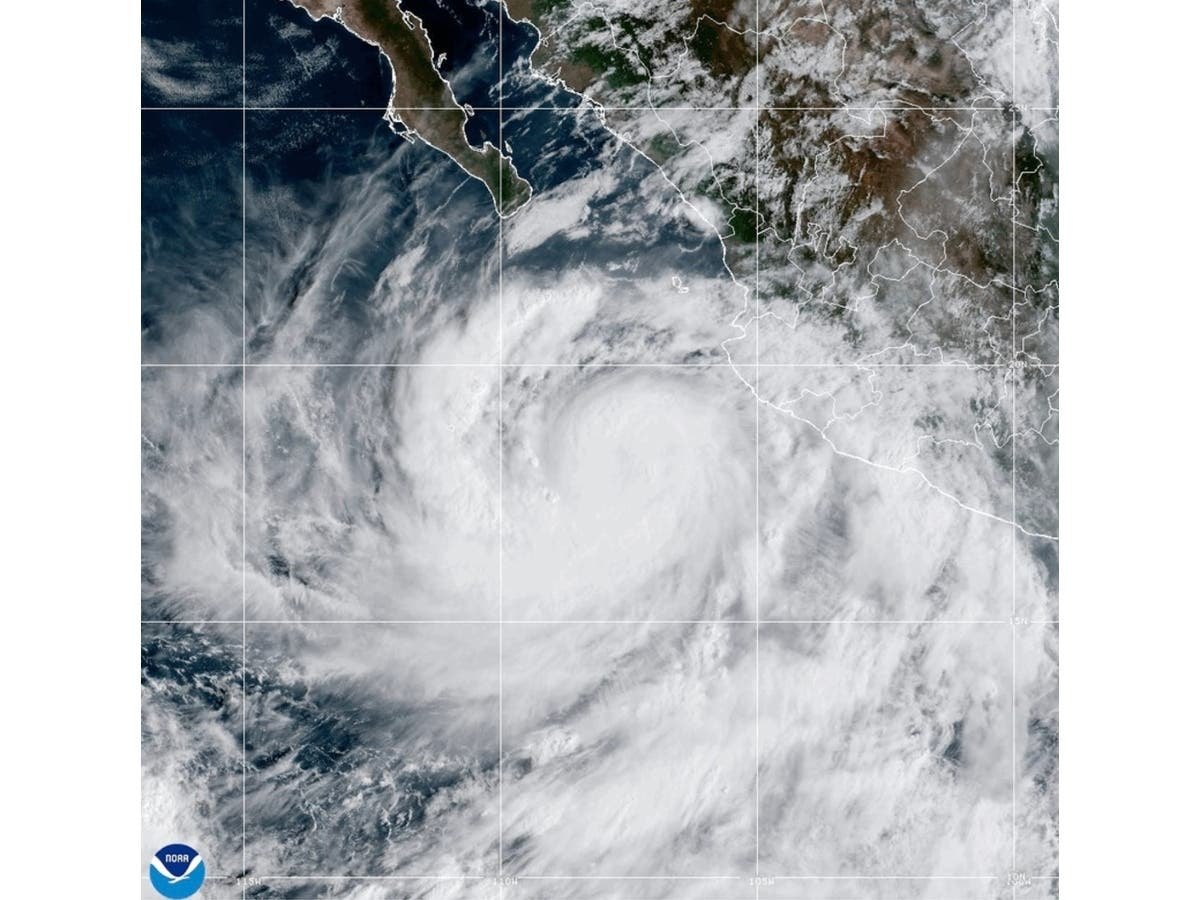
Tropical Storm Rachel is forecast to bring heavy rain, flash flood risks and wind gusts up to 30 mph to Temecula starting Saturday night. It marks the first tropical storm watch for Southern California since Hurricane Hilary in 2023, according to The Weather Channel.
The storm was about 400 miles south of San Diego as of 2 p.m. Saturday, Oct. 10, moving north-northeast at 30 mph, according to the National Weather Service in San Diego. Rachel is expected to make landfall in northern Baja California, just south of the U.S.-Mexico border, Saturday evening.
The heaviest impacts are forecast for late Saturday night through early Sunday afternoon.
The NWS point forecast for Temecula calls for heavy rain at times Saturday night, with a low around 61 degrees and gusts up to 25 mph. Sunday brings a 100% chance of showers, a high near 68 degrees and gusts up to 30 mph. Total rainfall of roughly 1 to 1.5 inches is possible across both days, according to the NWS Temecula forecast.
A flood watch is in effect from 11 p.m. Saturday through Sunday evening for the Riverside County mountains, the Coachella Valley, the San Gorgonio Pass near Banning and all of San Diego County, according to the NWS San Diego flood watch. The watch does not explicitly cover Temecula's valley floor, but Valley News reported that localized flooding is still possible in Southwest Riverside County communities including Temecula, Murrieta and Menifee.
The NWS warned that maximum hourly rainfall rates of 0.7 to 1 inch per hour are possible across area mountains. The agency said rivers and tributaries may rapidly overflow their banks, and small streams, creeks and arroyos may become dangerous.
The San Francisco Chronicle reported that the NWS has issued a moderate, Level 3 out of 4, risk of excessive rainfall capable of producing flash flooding from San Diego to Palm Springs on Saturday into early Sunday. Fox Weather reported that Riverside County is part of the area of greatest concern for flooding Sunday.
Sandbags available in Temecula
The City of Temecula is providing up to 10 free sandbags per household or business, available from 7 a.m. to 8 p.m. Saturday at five fire stations, Valley News reported:
- Station 12, 28330 Mercedes St.
- Station 73, 27415 Enterprise Circle West
- Station 84, 30650 Pauba Road
- Station 92, 32211 Wolf Valley Road
- Station 95, 32131 South Loop Road
Free sand for self-filling is available at Ynez Road and Santiago Road, Meadows Parkway and La Serena Way, and Patricia H. Birdsall Sports Park's east parking lots. Residents must bring their own shovels.
What's driving the storm
El Niño conditions and an ongoing marine heat wave have pushed ocean temperatures 10 to 13 degrees above normal off the California coast, according to the Los Angeles Times. Climate scientist Daniel Swain of UC Agriculture and Natural Resources said during a Friday briefing that the combination of warm water and an early-arriving low-pressure trough is fueling the storm.
"It's notable that this is an unusual event that's being made possible by both coincidence of this early arriving low-pressure trough off the coast of California and the record warm … ocean temperatures off the coast of California right now," Swain said.
Safety guidance
Valley News reported that motorists on Interstate 15, Interstate 215, state Route 76, state Route 79 and rural roads should watch for standing water, reduced visibility, fallen debris and sudden road closures.
The NWS urges residents to avoid driving through flooded roads, stay away from beaches and rocky shorelines, secure loose outdoor items and monitor local emergency alerts. People living in low-lying or poor drainage areas should plan to move to higher ground if conditions worsen.
Showers are expected to continue through Monday, with a high near 63 degrees. The NWS said its next storm update would be issued around 8 p.m. Saturday.